Saturday, October 26, 2019

The Rock Art of Hog Canyon.


Hog Canyon is located three miles west (mile marker 4 on Highway 211) from Newspaper Rock, there is a short pull-in area for parking.  The trails up to the walls (Blue Grama aka Blue Gamma – popular to crack climbers) are well worn, but the soil is loose.  Following the rock art itself entails maneuvering up and around boulders, sometimes squeezing between one that has split in two after its fall from the wall.

Trails are not marked and tend to be narrow.


Be prepared to climb over, between and around boulders.


Therefore, being 60 years old, overweight, diabetic, and arthritis in my hands, arms and shoulders means I cannot do this adventure, right?  Wrong!!!   There are people out there that are preaching that "young, fit and healthy" are 3 traits you must have to be able to adventure in the outdoors.  That is certainly the largest load of bull crap I've ever heard!  By the way, this is coming from folks who haven't even done 1/16th of the adventures that Roy and I have experienced.  What do they really know?  Obviously what some current fad is telling them to know, as they do not have a mind of their own.  No matter what your age, fitness level or health; get on out there and do something adventurous!  Life is a gift, but not guaranteed, so never say never and enjoy life!

My hubby, Roy.


Now back to our regularly scheduled write up of the latest Cokenour adventure.

Carved onto stone, drawn into the desert varnish, there are square-bodied humanoid figures, mountain sheep, insects, long leaves resembling ferns, circles and many other shapes and figures.  There is the occasional signature of those who settled or visited in the early 20th century (1911 – Ralph Hurst and Bill Dalley).  While many modern day traveler thinks that the Indian rock art is nothing more than “ancient graffiti”, they fail to understand that it was the earliest form of the “written word” for these cultures.


1911 Signatures amongst the ancient rock art drawings.


Like Shay Canyon, Capitol Reef National Park and Nine Mile Canyon, many of the figures are identified as Fremont culture.  For those saying, "Wrong, it's Anasazi"; identified tribes we know of, such as Ute, Navajo, Hopi, Zuni and Fremont were the Anasazi.  The Anasazi didn't "disappear", they simply branched off to create singular tribes in the areas they decided to call home. 

Oh, sorry, disclaimer necessary at the moment, "Visitor/Welcome Center Managers or Tour Guides, if you have not signed an agreement with me, and/or paid a yearly fee, you do NOT have my permission to download any content from this travel blog. You certainly cannot erase my name, put a different name on it, with the intent of giving away, or selling, to the public.  That is copyright infringement!"  

Ah, back to Hog Canyon...

Why the name “Hog Canyon”?  In Utah’s Canyon Country Place Names (Steve Allen), there is a reference to “Pete Steele noted that the canyon was fenced with knit wire (sheep wire) to hold the pigs that used to pasture in the canyon.  The fence still stands.  (1821~)”.  In the December 10, 2014 issue of the San Juan Record, Albert Eugene (Pete) Steele’s obituary states, “One of his jobs growing up was punching cows for the SS Cattle Company rooted deep in San Juan County’s history. His tales of the Old West and the history of San Juan County were a treasure to anyone lucky enough to hear them.” 

Great look out spot.

Climbers love these walls.


The rock art continues along the bottom of the crack climbing walls; so if you're going to climb, be aware and do not destroy!


Of course, as you make your way up to, and along, the walls, make sure to turn around and take a good look at the surrounding landscape.


Personally, I call these "The Three Graces"

...and my write up wouldn't be complete without a bit of plant and wild life.

Claret Cup Cactus

Desert Lizard


I would say that Roy and I spent about two hours climbing up, around and down from the Hog Canyon walls. It was a great workout!

Mary Cokenour

Tuesday, October 1, 2019

Hog Canyon Travel Guide.


Hog Canyon, so named for the pigs that ranchers once pastured there, is part of the Indian Creek Valley; and the northern section of the Bears Ears National Monument.  While narrow hiking trails lead up to the walls that are popular with “Crack Climbers”, ancient ancestral rock art cover the walls as well.  Carvings and drawings adorn the desert varnish with humanoid figures, animals, insects, fern leaves, circles and many other shapes.


·         Location is 29.4 miles northwest of Monticello.  Take Hwy. 191 north for 14.4 miles, make a left onto Hwy. 211 and continue for 15 miles.  Newspaper Rock is 12 miles along Hwy. 211, Hog Canyon is located 3 additional miles west and located at mile marker 4.  There will be a dirt pull-in area on the right hand side of the roadway; narrow trails up to the rock face can be seen and followed up to the rock art.


·        Difficulty: Easy to Moderate; due to the falling of rock off the walls, it will be necessary to maneuver around, or climb over, boulders.  The dirt is loose on the trails, so wear appropriate hiking shoes/boots plus carry a walking stick, if necessary, for added stability.

·        Admission: Free

·        Facilities: None at this location.  Vault toilets are located at Newspaper Rock.  Any trash should be taken out and placed in refuse bin.

·        Camping: There are five (5) BLM campgrounds located along Hwy. 211

·        Pets: Allowed, owners are expected to clean up after pet(s).  Hwy. 211 is a much used roadway which leads to Canyonlands National Park– Needles.  For the pet(s)’s safety, keep aware of their location and surroundings.

As with any site containing ancient rock art, this is a historical area, so look, but do not touch nor deface.

Mary Cokenour


Friday, September 13, 2019

16 Room Cliff House Travel Guide.


16 Room House, aka 15 or 17 Room House (disagreement among archaeologists on the correct number of rooms in the pueblo), is an Anasazi cliff dwelling stretching across a massive alcove.  Windows within the rooms look down upon land that may have been used for farming, and the San Juan River.  Pictographs on the walls contain a large number of hand prints.


·         Location from Monticello is 107 miles using CR 441 route, or 111.1 miles using CR 438 route. Travel 58.1 miles along Hwy 191 (make a left turn at the junction of Hwy 191/163 to continue on Hwy 191).  This area is Navajo Reservation land, please remember to stay on designated roads and do not trespass onto private lands. There are two ways to get to 16 Room House, County Road 441 (maintained dirt/gravel road) for 6.9 miles to the junction of County Road 438, then 4.8 miles along CR 438 (maintained dirt/gravel road this section only) to the ruin site.  Or continue down Hwy 191 for three (3) additional miles to County Road 438 which is paved for eight (8) miles before the junction with CR 441, then continue the 4.8 miles to the ruin site.


This altered map is from an original from gjhikes.com


·         Admission: Free

·         Difficulty: Trail up to ruin site is extremely steep and narrow before a narrow ledge to enter the various rooms along the alcove.


·         Camping: Not Allowed

·         Pets: Not Allowed

·         Facilities: None, nearest town (Bluff) is 25.1 miles.

We spent several hours exploring the ruins and taking the short trail down to the San Juan River.

Mary Cokenour 


Wednesday, September 11, 2019

Monument Valley At Any Time.

Monument Valley , for the majority of residents, and visitors to the area, is an awe inspiring destination; one of those "must experience" places.  It's span is over two states: Arizona and Utah; in Utah, it is part of the largest county in the state, San Juan.

During the spring and fall equinox, the shadow of one Mitten forms atop the second Mitten.  It's a big deal and hundreds flock to the Valley to witness the event.  Yes, even Roy and I have done it; along with a couple of friends, and it's really like a party atmosphere.  Then we ride over to Goulding's Lodge, and the Stagecoach Dining Room, for a great meal.

The photos I'll be sharing were taken during the day and at sunset; sunny sky to cloudy.  One photo of Eagle Rock-Eagle Mesa even has the hint of a rainbow after a short rain storm.  While many of the monuments can be seen from Hwy. 163, I do advise to not be cheap.  Either go into the Tribal Park itself and find a tour guide; or go to Goulding's Lodge and sign up for one of their 3 hour, or all day, tours.  This way you will see monuments up close and personal that are not seen from the highway, ruins, rock art, and the way the Navajo people live in this area.

Sort of funny story time:  I was working at the local visitor center and a woman from Belgium came in.  She had visited Monument Valley and was quite disappointed.  Why, you wonder?  She had seen the Johnny Depp movie, The Lone Ranger, which had much of it filmed within Monument Valley.  Here she was, on vacation, and nowhere could she see, "Where the Indians really lived".  She complained that there were "real houses" down in the Valley, "Where were the teepees!?!"  The people wore clothing like any other person, "Why weren't they in real Indian clothes; the men wearing loin cloths!?!"

I explained that the film was geared towards the late 19th century (1880s) to early 20th century.  The Native Americans were just like anyone else...people.  They lived in houses like anyone else; wore clothing like anyone else; they were like...anyone else.  Unfortunately this didn't make her any happier as now she felt that she had watched a movie that, sort of, lied to her about the southwest.  So there you have it folks, the USA, or parts of it, is perceived dependent on the film created by Hollywood.

When you go to Monument Valley, visit the museum at the Tribal Park's visitor center to get a true history lesson.  Better yet, go on one of the tours led by residents of Monument Valley; get an up close and personal history lesson about the Navajo culture.

Oh, speaking of films, I am including a film that I took as we traveled to and through the Valley.  Originally it was 13 minutes long, but hubby, who owns Desert Stone Studio , was able to cut it down to a more manageable length of time for viewing pleasure.  Basically you'll get a gist of what you'll be seeing as you make the drive along Highway 163.

Enjoy the journey!

Mary Cokenour

Monument Valley Photographs

Eagle Rock - Eagle Mesa, rainbow after rain storm

Eagle Rock - Eagle Mesa

The Mittens and Merrick Butte - As Sunset Progresses Over a 10 Minute Span


Sentinel Mesa and Big Indian Butte
 View from Goulding's Lodge


Agathla Peak - Arizona side of Monument Valley, along Hwy. 163
Video - Monument Valley Via Hwy. 163


Tuesday, September 10, 2019

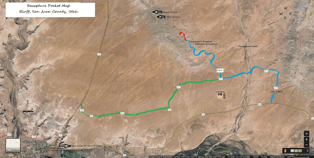
Recapture Pocket, or San Juan County's Hoodoo Park, Travel Guide.


Recapture Pocket is an area of badlands near Bluff, Utah; like Goblin Valley, it is a sand filled landscape with hoodoos of all shapes and sizes.


·        Location is 54.1 miles from Monticello; travel 45.9 miles along Hwy 191 to the junction of Hwy 162 in Bluff (Cow Canyon Trading Post on SE corner).  Start at the Trading Post to be able to get to the 4.9 mile mark, not at the sign that says “Mile 0”.  The road to make a left on has 2 names when looking at an area map (CR 2401 and CR 217), there will be a yellow “cow sign” with a “cattle crossing” sign underneath it, make the immediate left.  If a 2nd cow and cattle crossing sign are passed, you have gone too far.  After the initial left turn, there will be a split 9/10ths of a mile in, take the left hand split and go 4/10ths of a mile.  Make a right turn onto CR 249 (Bluff Bench); another split will be reached at 7/10ths of a mile, go left again.  Hoodoos (unusual sandstone formations) will be seen, but it will be 1.3 miles before Recapture Pocket itself is reached.


·         Admission: Free

·         Difficulty: Hiking – Easy; Vehicle: This area is completely desert terrain; 4-wheel drive vehicles will need high clearance due to deep dips on sandy trails and some travel over rocky ground.

·         Camping: Yes; pack out what is packed in.

·         Facilities: None; nearest town (Bluff) is 8.2 miles.

·         Pets: Allowed, owners are expected to clean up after pet (s).

·         Caution: Flash flooding will occur over roads during long and/or torrential rainstorms; once water recedes, sandy trails will be extremely muddy.


Mary Cokenour

Monday, September 9, 2019

Pioneer's Travel Guide to River House Ruin.

River House Ruin/Rincone Trading Post/San Juan Hill Via the Pioneer Trail

River House Ruin is located near the San Juan River on the west side of Comb Ridge. The ruin has multiple one and two story rooms, granaries, a kiva, petroglyphs and pictographs.  


Location from Monticello is 58.6 miles; travel 50.7 miles south along Hwy 191, continue on Hwy 163 for 3.1 miles which goes through the Comb Ridge pass.  ¼ of a mile, make the first left onto County Road 2351.


CR 2351 is part of the Hole in the Rock Pioneer Trail and the attempt to find a way over the Comb Ridge.  The entire trail is mainly sand, crossing into and out of several dry washes, and climbing several steep hills for almost four miles.  There are green wooden posts with a covered wagon painted on to mark the trail.

The first informational board is a short history of this section of the pioneer trail; the second will tell which way to go when encountering the first fork in the road; go left and follow the curve around the bushes.  4/10ths of a mile down is Navajo Spring; the pioneers sent out scouts to see if this was a viable way up and over Comb Ridge.  


4 miles is another divide in the trail; the one to the right leads down to the San Juan River and ends.  The trail left turns into pure stone; a series of uneven "steps" upward that leads to the San Juan Hill, Rincone Trading Post and River House Ruins trails.

Total Mileage: 4 miles to the trailheads for River House Ruin, Rincone Trading Post and San Juan Hill.

Total Mileage to River House Ruin is 4 miles.   

Difficulty: Easy for Hiking; Vehicle: 4-wheel drive with high clearance is a must; independent 4-wheel suspension is suggested for the uneven “steps” leading to the trailheads. 

Admission: Free

Camping: Allowed; pack out what has been packed in.

Pets: Allowed; owners are expected to clean up after pet (s).

Facilities: None; nearest town (Bluff) is 12.4 miles.

Rincone Trading Post was established in 1880 by William Hyde, he later partnered up with the Bartons.  Read the interesting history pertaining to the Rincone in the book, Comb Ridge and its People, by Robert S. McPherson.


Location is two (2) miles along the trail to River House Ruin.


San Juan Hill is the location the pioneers finally chose to move their wagon train upward and over the Comb Ridge.  Wagon wheel tracks and chiseled foot holds for animals can still be seen on this very steep, rocky trail.


Location of trailhead is 1.5 miles along trail to River House Ruin.

Bring lots of water, snacks and a picnic; this is an all day excursion and worth every moment.

Mary Cokenour