Wednesday, June 10, 2015

Shearing Pen Road and Posey's Last Shot.

Traveling to and from the Bluff area (remember, we're trying to find all the sites listed in the "Around Bluff" pamphlet), we often see a road going out to the beyond and wonder, "Where does it go?"  So it came to be one Sunday, on the way to finding 16 (or 17) Room House (I will be writing about it), that we decided to explore one of these roads outside of Blanding.

Shearing Pen Road (CR 210) is only about four miles before it ends at an overlook of Corral Canyon.  It's a beautiful area, and sitting on the slickrock ledges, having lunch, made the experience even that much better.  Oh, I should tell you how to find it; 5.8 miles from the Blanding Visitors Center, travel south on Route 191 till you see, on the left, a dirt road winding up a hill.  Every time we have passed by, we saw a welcoming committee at the entrance, so you may look for them as well.
Shearing Pen Road Welcoming Committee
At 6/10s of a mile, the road splits, Shearing Pen continues straight on; however the road to the left eventually loops back to CR 210 and is named "Posey S (Posey's ?) Last Shot".  Now it seems that Roy and I are traveling over history backwards; first we went to Posey's Trail Road (CR 240) where Posey tried to escape from the sheriff, but was killed.  Now we've found the place that lead to the chase, and the story is detailed in the book, "Posey - The Last Indian War" by Dr. Steve Lacy and Pearl Baker (pages 134 - 139).  The gist of it was that Posey, a Paiute chief, was getting his band together; the sheriff and his posse were riding to Corral Canyon to waylay them when a shot rang out.  A blue-roan horse, named Old Blue, was killed and while no one had actually been seen doing the shooting, Posey was accused and the chase was on.

The end of CR 210 had evidence of camping, and like I mentioned before, it's a beautiful spot for having a simple picnic.  We did see an ATV trail below, we could see where it ended, but not where it started as it wound around a small hill.  Where we sat, we could also see traffic as it moved along Route 191; the tops of 18 wheelers that is.

Corral Canyon


Route 191 is far in the distance.


The quiet was divine, only broken by the call of a hawk to its mate; I was able to get a photo of one of them in flight.


A short, but very serene drive down a road with Native vs. White Man history; you can take the history, we'll stick with the serenity.

Mary Cokenour

Saturday, June 6, 2015

Mexican Hat - A Tale of Two Bridges.

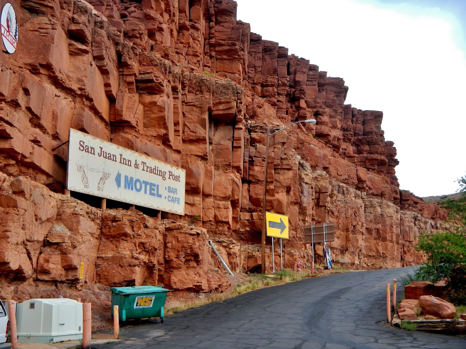
Mexican Hat, named after the famed sombrero formation, has a history rich in oil, gold prospecting, and uranium/vanadium mining.  In 1882, this small town was first named “Goodridge”, after E.L. Goodridge who came to the area in hopes of striking it rich on gold.  Like the Beverly Hillbillies, up from the ground came a bubbling crude; oil that is.  1906 to 1910, a man named Neville built and ran a trading post north of the San Juan River; but it was Jim Hunt who took it over and built the inn.

San Juan Inn
Over the San Juan River, the bridges that have come and gone have their own colorful history.  The original suspension bridge burned down and a second was built; wooden planking held many a horse drawn wagon, motorized vehicles, two legged to four legged walkers. 


E.L. Goodridge and his Mexican Hat Bridge


Update, July 6, 2016: In the book, "Looking Back Around the Hat,  A History of Mexican Hat"
by Doris Valle, there is mention of Emery Langdon (E.L.) Goodridge rebuilding the bridge as he was founding Mexican Hat (1882-1883).  (see side photo) 

Thanks to my friend Amy for digging around archives and finding this little gem.


However, prior to Goodridge's arrival in 1882, another bridge was there; the river could rise a good 40 plus feet, so it was not unusual for a bridge to wash away, and another built to replace it.  John Wetherill (top photo), and Charles Spencer with his pack team (bottom photo) were photographed crossing the bridge over San Juan River. 

Photos Courtesy of Harvey Leake (a descendant of the Wetherills).


1909 - 1910: Sheep were the commodity crossing the bridge.
Source for Sheep Photo: "River Flowing from the Sunrise: An Environmental History of the Lower San Juan"
by James M. Aton
http://digitalcommons.usu.edu/cgi/viewcontent.cgi?article=1127&context=usupress_pubs


During the 1940s to 1952 (around the time the San Juan Inn was built), this small, narrow suspension bridge across the San Juan River could not support large trucks. The ore, hauled from mines in Cane Valley and central Monument Valley, would be transferred to smaller trucks, transported across, and then transferred back to five-ton trucks which brought the ore to a stockpiling area about a mile north of Mexican Hat.  In 1952, construction began on an all steel and concrete “arch” bridge (completed in 1953) which would support the full weight of the larger ore hauling trucks.
Photo by Fred Blackburn; taken sometime within 1955-57 of the two bridges side by side as he traveled to Monument Valley with his family.
 

This story comes from the father of Amy Watkins Kensley, teacher at the Monument Valley Elementary School:

In 1953, the driver of a small truck hauling a bobcat tractor (as large as a D6 John Deere tractor) chose the wrong bridge to travel over.  The full weight of both vehicles caused the planking to give way about halfway across; it all fell into the San Juan River, but, surprisingly, the driver was not injured.  While being repaired, the work crew placed a wooden panel over the broken section; the bridge was closed down to all traffic.  One day, a man asked if he could ride his horse over the suspension bridge, but was told no due to safety issues.  However, the next morning, the work crew came upon the man attempting to ride his horse over the bridge anyway.  It was very apparent that the horse did not want to go (horses being smarter than humans at times); however, they both made it across safely.


In the 1970s, the suspension bridge had become obsolete and was finally dismantled which brings me to the Olde Bridge Grille (formerly Old Bridge Grill Café and renamed in 2007).  Well, not on this post; you'll have to go over to my food blog for the write up, and photos, of the food.  Click HERE

Mary Cokenour


UPDATE:  Spoke with geologist, river runner and Bluff resident, Gene Stevenson, on June 10, 2015, who was able to confirm that the old suspension bridge was not dismantled, but actually fell apart and down into the San Juan River in 1975.

Just in case anyone wants to know where I obtained my information about the Mexican Hat Bridges...

1 - "Tony Hillerman's Navajoland: Hideouts, Haunts, and Havens in the Joe Leaphorn and Jim Chee Mysteries" by Laurance D. Linford; published 2001, beginning page 176.

2 - Blue Mountain Shadows, vol 16, page 86, story by Dick Wing (oil driller) who told story of Mexican Hat bridge burning down in early 1900s.

3 - The Mining Investor (newspaper), February 5, 1912 article about bridge being rebuilt again after the 1909-10 bridge was destroyed by flooding; page 209.

4 - Verbal history related to me by Amy Watkins Kensley's father.

5 - Photograph and verbal history related to me by Fred Blackburn (co-author of "Cowboys and Cave Dwellers" (1997)).


Update, July 5, 2016:  Bridge Dedication for Jason R. Workman, a Navy Seal killed in 2011.

Article Courtesy of San Juan Record: http://www.sjrnews.com/view/full_story/27147597/article-San-Juan-River-Bridge-renamed-to-honor-fallen-hero?

Photo Courtesy of Rob Mador via Facebook.com:


Photo Courtesy of americasbrave.last-memories.com
 

Wednesday, June 3, 2015

An Afternoon in Bluff.

Lately, Roy and I have been spending leisurely afternoons down in the Bluff, Utah, are; then meeting up with our friend, Amy, for dinner.  Lets say we are on a quest, a quest to see all the sites listed in the "Around Bluff" pamphlet given out at Bluff Fort Museum and Visitors Center.  A map will help you with today's post, especially since I filled in added details.


Two of the famous attractions in Bluff are the Navajo Twins and Sunbonnet formations located at the Twin Rocks Café and Trading Post, but we didn't stop here this time.  Instead, we drove past and onto County Road 723 which took us to Calf Canyon, and another formation called The Locomotive.  To me, The Locomotive seems to be more of a focal point of the Bluff area than the Navajo Twins.

The Locomotive


Calf Canyon is a peaceful area to hike around in; we found a large stone slab with various rocks placed upon it.  Looking from above, we could make out the form of a spiral; someone's idea of an altar or sacred space?


A long while back, I had seen a photo in our local paper, The San Juan Record, of The Locomotive as viewed from the cemetery.   Going back towards Twin Rocks Café, we made a right turn before getting to it and ended up on Red Rock Road (aka Cemetery Road).  We did see a sign about the cemetery, and a ruin site, but this is where it gets a bit confusing.  We saw a road that curved upward, but it looked like it was going to a Native style home; but continuing straight on brought us to "Residents Only" streets.  Out came the GPS and to our surprise, that upward curved road was the one we were supposed to be on.  Yeppers, we drove right on past that Native style home, and came upon the Great House/Great Kiva kiosk.

Built around 1100 A.D., the Great House is an example of Chacoan culture; several rooms in which some had two stories.  The Great House was reburied to keep it preserved.  While the Great Kiva is partially buried for preservation, there is a section open to the public for exploration.


View from the hill where the Great House stood.

Trail to the Great Kiva; sheltered by wooden structure.


Some of the original plaster still adheres to the Kiva's walls.
At the end of this road is the Bluff Cemetery; small, quaint and the resting place for the first Mormon settlers in San Juan County, as well as their descendants.


With no actual plan in mind, we ended up on Route 191 again heading out of town in the direction of Mexican Hat. We did not get very far at all, but saw a sign for "Bluff Transfer Station" and said, "Oh what the heck!".  This 4-wheel drive road is 2.4 miles from Bluff Fort, and the "transfer station" is basically the dump.  It was a bumpy, yet relaxing drive out into the desert when at the 1.3 mile mark I yelled out to Roy, "Hoodoos!"  This trail ends at the 1.5 mile mark and we saw a "hoodoo spire".  Now the interesting part of this is that these hoodoos are not the hoodoos that are mentioned in the "Around Bluff" pamphlet.  We're going to try and find those within the next week.


Still time before meeting Amy for dinner; it was her birthday by the way, and we were taking her to Cottonwood Steakhouse.  So a detour onto County Road 2691, or the road to the Bluff Airport, called to us.  We rode all the way down to the hangar and tarmac with a mutual thought of, "Well now, that was anti-climatic."  That is until I looked outside my window and there, close to the ground, were two signs, "Gold Mine Access Road" and "San Juan River Road"...jackpot!  Now this ended up being, on one hand, disappointing because we could not get near the gold mine to see what it was about.  However, we did get all the way down to the river and that was glorious!  It's quiet and the sound of the flowing water is so soothing.  There was evidence of camping down there, and we figured that, in the future, this would be a perfect place to have a picnic.  One strange occurrence though was seeing all the smiling faces staring at us from across the river.  Looks like someone, or maybe a few, decided to shoot at the red rock walls across the river, and create their own version of "rock art". 


Blooming Prickly Pear Cactus
On the way back to Route 191, there was a small plane at the airport, and the pilot waved to us.  I had Roy stop, so I could take photos of flowering plants; the plane flew overhead and we waved.  Don't know if the pilot saw us, but it was a nice ending to this adventure.  We met our friend at Cottonwood Steakhouse, had a great meal as usual; it was a perfect afternoon in Bluff.


Crescent Milkvetch (Pea family)


Halogeton (Goosefoot family)

Hopi Blanketflower (Sunflower family)


Prince's Plume (Mustard family)

San Rafael Prickly Poppy (Poppy family)

Mary Cokenour